


Having information about all the people evicted in the process of evacuating a building is a fundamental fact. Currently this is achieved thanks to emergency procedures, emergency communication systems, and pre-event emergency training. The study of human behavior in fires has allowed the development of the aforementioned procedures and it has also been used to model the evacuation movement in computer simulation (Kuligowsky 2015). The data on which that study has been based on arose from the testimony or interview of the people involved, generally at a later time (Kuligowsky 2011). This inspection can be electronic, on paper, “face to face”, or by phone (e.g Butler et al., 2017, Haghani and Sarvi 2017), using individual questionnaires that ask about the subjective perception of the people evacuated. The other source of data consist on the recording of human behavior in strategics points, either in evacuation drills or in controlled experimental environments: Real space built for the experiment (e.g. Lian et al., 2017, Liao et al., 2017), real space selected for the experiment (e.g. Zhu and Shi 2016), in tunnels (Capote et al., 2013), in a real evacuation drill, e.g. in a theater (Lovreglio et al. 2015), or in a six-storey office building (Ronchi et al. 2014). Another source of data is the use of virtual controlled experiment using virtual reality (e.g. Kinateder et al. 2018, Lovreglio et al. 2016).
In this paper we propose the use of the technology of indoor (non-GPS) localization systems to build a new tool to collect individual data on human behavior in evacuations drills. (GPS technologies are discarded, because in general they do not work in indoor environments.) The data obtained in this way can both be used to make decisions in real time (such as rescue people) and to perform analysis at a later time. Besides, this opens the possibility of obtaining data on human behavior in the evacuation, including times, routes, decisions, agglomerations, bottlenecks, etc, in a more objective and detailed way than with the use of individual and collective monitoring.
There are already published applications where indoor location is used in emergencies cases. One of them consists on the use of mobile phones with the purpose of employing real-time sensor data as references for evacuation route calculation. For example Wang et al. (2014) and Wand et al. (2015) make an attempt to convert sensor systems to sensor graphs and associate these sensor graphs with route graph in order to dynamically generate evacuation adapted to the risk. In their work, Seo et al (2017) proposes the use of beacons and Unmanned Aerial Vehicles in emergency response systems for building fire hazard. They present a proof of concept prototype of a monitoring and emergency response method. Finally, Aedo et al. (2012) use indoor location to adapt information to the context and the profile of each person in order to provide personalized alerts and evacuation routes to all kinds of people during emergency situations in working places.
The use of these technologies in this context is not just a technological matter, but also to find or develop systems that can fulfill their requirements with sufficient quality at an affordable cost.
There are several localization technologies that can be applied to solve different problems, being in many cases complementary systems. Related technologies include the use of WIFI signals (12-meters precision, medium cost), Bluetooth Low-Power (BLE) devices (few-meters precision, low cost), and Ultra Wideband (10-cm precision, high cost). In this work we propose the use BLE technology to instrument the evacuation of a University building, describing the lessons learned, showing how this technology allows to know the preferred evacuation routes, detect bottlenecks and accurately measure evacuation time.
The study of evacuation drills in large and/or complex buildings requires a large number of observers located at strategic points of the building, to be able to collect data from the evacuation exercise. Human observers represent a significant cost to the organization. The use of cameras instead of human observers is also expensive, and poses additional bureaucratic barriers related to image registration and data protection issues.
Our proposal in the PERIL project is to test the feasibility of using indoor positioning technologies to assist in the localization of people in an emergency drill. To do so, the PERIL project included the development of an indoor positioning system composed by a set of transmitters (beacons), receivers (antennas), and a cloud-based service to offer real-time, on-map positioning and to store historical data.
As transmitters, we use low cost, reduced size (1.5 cm) and low consumption (4 years of autonomy) LEB beacons that can be carried by people to be locatable.
A set of low-cost receiving antennas should be conveniently distributed in the ceilings of the space to be monitored (in our case, the School of Informatics at the University of Valladolid). These antennas collect the emissions from the beacons, and estimate the distance between each beacon and themselves. This information is sent to a cloud-based service, which uses it to locate each beacon inside the building with the help of trilateration algorithms, and to draw the position at real time in a web-based browser.
We have conducted in May 2018 an evacuation drill at the School of Informatics, a building of the University of Valladolid, in Valladolid, Spain. A total of 31 receiving antennas have been placed in the building, mainly in all the exits of the building and accesses to the staircases from the different floors. One antenna was placed in the meeting point, outside of the building.
34 volunteers have carried a beacon during the evacuation drill, allowing the indoor positioning system to record their movements and routes used during the evacuation process. Part of the volunteers were observers of the drill that received the instruction to perform the evacuation integrated with the group, following the instructions of the members of the evacuation team but trying to be the last person to abandon the building. The remaining beacons were carried by normal building users. A total of 500 people evacuated the building.
The system allowed to collect and store the signals emitted by all the beacons, calculating the position of the 34 beacons at real time during the evacuation drill. Each beacon had an unique tag, and it emits their position four times per second. The antennas collect that information and use it to estimate the distance to each beacon.
The data collection is not homogeneous: Each tag has a different number of samples over time. During the data collection process, a software problem generated a signal blackout that affected the reception of all beacon signals during several seconds. However, the system was robust enough to recover on its own, storing the collected signals without additional losses. A total of 19,697 positioning values were stored for further study.
Times are recorded in milliseconds from the Epoch (Jan 1st 1970). The first sample was received at time 1525341014104, associated to beacon 22. The last sample was received at 1525341899151, so the entire monitoring of the evacuation drill lasts for 885 seconds.
The position in space is defined by x, y, z coordinates, where the z indicates the floor (0 for the basement, 1 is the ground floor, 2 is 1st floor, and 3 is 2nd floor). Fluctuations are possible when people move between floors. The values of x and y are between 0 and 1, and are referred to the 2D-projection of the building map, with (0,0) corresponding to one end of the building floor and (1,1) to the diagonally opposite end. Positions outside this range correspond to beacons that left the building towards the meeting point.
The designed system also allows to see at real time, in a website with restricted access, the position and movement of the beacons with their tags in the different floors of the building. The positions are plotted on the plans of each floor of the building, allowing to see simultaneously all the beacons that are on a floor and their movements.
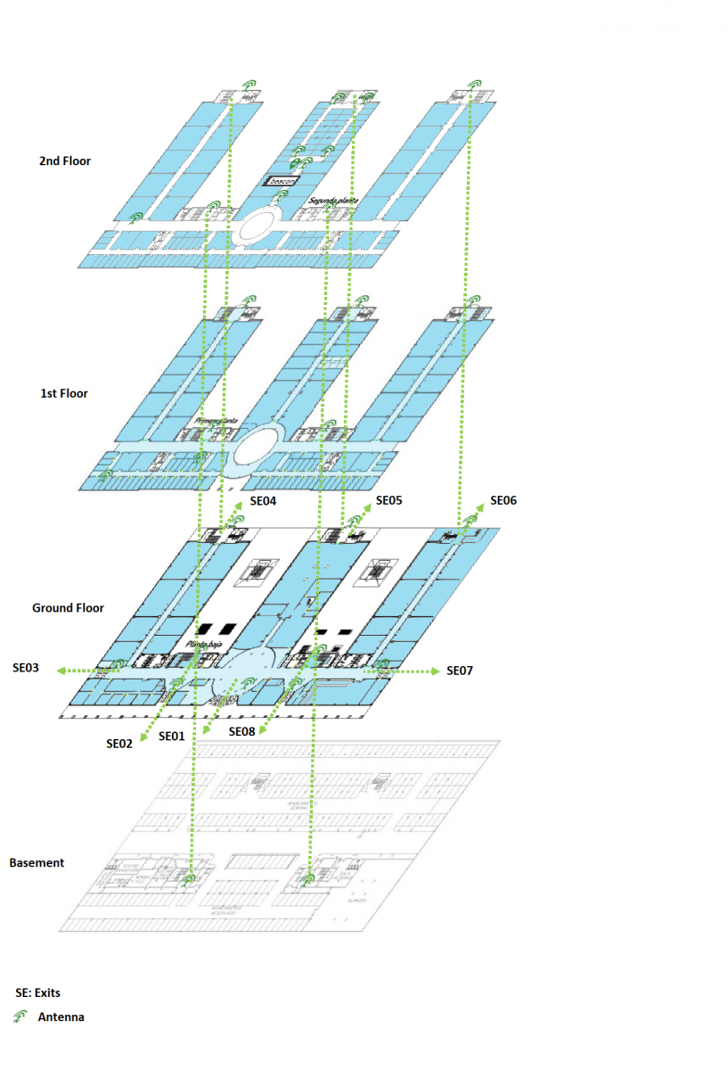
Figure: representation of building and antennas
The evacuation drill experience with the use of the indoor location system developed in the PERIL project has provided 19,697 positions of 34 people during the 885 seconds that delimited the drill, of a total of 500 evacuated people. These positions have been viewed in real time by authorized users connected to the website, so they can see how the evacuation was developing, allowing the detection of anomalous behaviors. Real-time visualization provides the opportunity to have more and better information so that those responsible for the drill can make decisions in the event of difficulties in the evacuation.
The storage of information in a cloud-based service outside the building, in order to both prevent their loss and to allow to further study the individual and collective behaviors, in order to improve protocols and evacuation conditions.
The system has proven its robustness, being able to recover from a software bug (a NaN division) that did not arise in previous tests. This failure gave us the opportunity to improve the system.
It also allows to have objective and quantified data of human behavior during simulated emergencies, allowing its future use in real environments.
The location of all people at real time would be desirable to ensure their safety and abandonment of the building in case of evacuation. However, it is important to find a compromise solution with respect to privacy in places of these characteristics. In other types of enclosures, where access security issues are restricted, for example, nuclear power plants, high-risk laboratories, etc., those responsible can decide to make the use of such a system mandatory.
We have presented a system that allows the collection and storage of objective data in an evacuation drill. The data is accessible at real time with a web-based interface that allows the persons in charge to visualize where each person is on the building map.
This new approach to the study of evacuations has two main advantages. First, it allows to use the information at real time, which improves the decision-making process for the optimal management of the evacuation. Second, the data is stored in a cloud-based service outside the building, in order to prevent their loss and to allow their use for further study and analysis. This analysis would both allow to look for ways to improve the emergency protocols, and to study human behavior in emergency evacuations, to be able to contrast current mathematical models with real data.
Through the application of the location of the individuals inside the buildings in evacuation drills, and then in emergencies themselves, we are able to evolve the traditional model towards a more dynamic management of evacuations. This will allow obtaining data to study the individual human behavior in the evacuations at an affordable cost. The key to these new opportunities in the field of emergencies is to adapt and customize the tools of indoor location and IoT to the needs of these cases. This is the goal of the PERIL project (Prevention of Emergency Risk by Indoor Localization).
The PERIL initiative is supported by the Castilla y León regional government (Spain) within the Universitas program, that supports research projects carried out by the public universities of Castilla y León in the field of occupational health and safety. This work has been partially supported by the Consejerı́a de Empleo, Junta de Castilla y León, Spain
(PERIL project, UNIVERSI/17/VA/1, and PERIL II, INVESTUN-18-VA-0001). We also would thank Daniel Barba for his contribution to the development of the software solution, and to all the volunteers, the School of Informatics, and the School of Telecommunications Engineering at the University of Valladolid, for their collaboration.
Aedo, I., Yu, S., Díaz, P., Acuña, P., Onorati, T., 2012. Personalized Alert Notifications and Evacuation Routes in Indoor Environments. Sensors (Switzerland), 12, 7804-7827.
Butler, K., Kuligowski, E., Furman, S., Peacock, R., 2017. Perspectives of occupants with mobility impairments on evacuation methods for use during fire emergencies. Fire Safety Journal 91, 955–963.
Capote, J., Alvear, D., Abreu, O., Cuesta, A., Alonso, V., 2013. A real-time stochastic evacuation model for road tunnels. Safety science 52, 73–80.
Haghani, M., Sarvi, M., 2017. Stated and revealed exit choices of pedestrian crowd evacuees. Transportation Research Part B: Methodological 95, 238– 259.
Kinateder, M., Comunalea, B., Warren, W.H., 2018. Exit choice in an emergency evacuation scenario is influenced by exit familiarity and neighbor behavior. Safety Science, 106, 170-175.
Kuligowski, E. D., Hoskins, B. L., 2001. Analysis of Occupant Behavior During a Highrise Office Building Fire. US Department of Commerce, National Institute of Standards and Technology Gaithersburg, MD.
Kuligowski, E. D., 2015. Burning down the silos: integrating new perspectives from social science research. In: Proceedings of the 6th International Symposium on Human Behaviour in Fire, Interscience Communications Ltd: London. pp. 1–12.
Lian, L., Mai, X., Song, W., Richard, Y. K. K., Rui, Y., Jin, S., 2017. Pedestrian merging behavior analysis: An experimental study. Fire Safety Journal 91, 918–925.
Liao, W., Wagoum, A. U. K., Bode, N. W., 2017. Route choice in pedestrians: determinants for initial choices and revising decisions. Journal of The Royal Society Interface 14 (127), 20160684.
Lovreglio, R., Ronchi, E., Nilsson, D., 2015. A model of the decision-making process during pre-evacuation. Fire Safety Journal 78, 168–179.
Lovreglio, R., Fonzone, A., Dell'Olio, L., 2016. A mixed logit model for predicting exit choice during building evacuations. Transportation Research Part A: Policy and Practice, 92, 59-75.
Ronchi, E., Kuligowski, E. D., Peacock, R. D., Reneke, P. A., 2014. A proba- bilistic approach for the analysis of evacuation movement data. Fire safety journal 63, 69–78.
Seo, S., Choi, J., Song, J., 2017. Secure utilization of beacons and UAVs in emergency response systems for building fire hazard. Sensors (Switzerland), 17, 10.
Wang, J., Winter, S., Langerenken, D., Zhao, H., 2014. Integrating Sensing and Routing for Indoor Evacuation. Geographic Information Science. GIScience 2014. Lecture Notes in Computer Science 8728.
Wang, J., Zhao, H., Winter, S., 2015. Integrating sensing, routing and timing for indoor evacuation. Fire Safety Journal 78, 111-121.
Zhu, K.-j., Shi, Q., 2016. Experimental study on choice behavior of pedestrians during building evacuation. Procedia Engineering 135, 207–216.
Papers relacionados